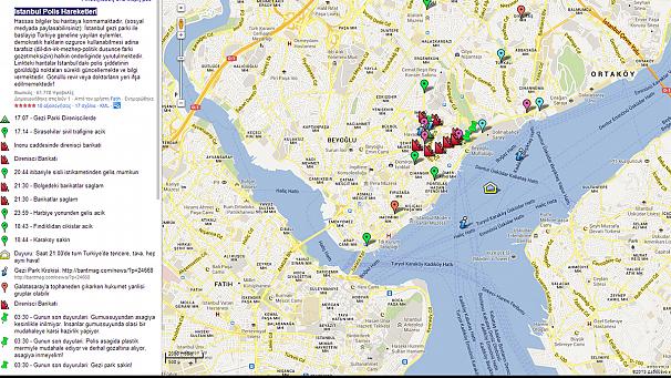
With crowdsourcing becoming evermore popular, it may not comes as a surprise that Turkish protesters have been using Google Maps to track police movements during the recent protests.
 They create the Istanbul Polis Hareketleri which means Istanbul Police Movement.
The map centers on Taksim square, the hotbed of protester activity against Prime Minister Recep Tayyip Erdogan’s government. It was created on June 1 following plans by Edogan’s government to renovate an Ottoman barracks.
This project required the razing of trees from nearby Gezi Park. Turkish protesters managed to prevent this using Google Maps by demonstrating in defense of the green space for over a week.
Mapping protests and police movements, while still relatively new, has happened before. Student protests that occurred in London during 2010 also made use of a Google Map to keep track of riot vans and helicopters moving against the protesters.
Some of the tactics employed by Turkish protesters have been likened to medieval tactics, most notably barricades, which are effective at keeping vehicles, police, and even horses away from the protesters. They also take time to tear down, and, in the event of police deciding to use violence, can provide excellent cover from gunfire and thrown objects such as tear gas grenades.
These kinds of tactics proved so successful in the past that some cities such as Paris, known for its regular protests, even redesigned their streets to make them less convenient for the construction of barricades.
Apart from Turkish protesters using Google Maps to mark barricades, some of the other markers include:
– A green tent to mark the heart of Taksim Square
– Road warnings in green, letting people know which one are open and which are blocked
– Pink tags for groups announcing who they are and where they are protesting
– Light blue flags for police locations and reported movements
– Warnings of police tracking servers online, confusingly under light blue as well.
Euronews


