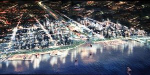
Efforts are underway for the start of the ‘crazy’ Kanal Istanbul project as well as for the metropolis’ new third airport. Five villages located in the axis of the third airport are now being sent out expropriation notifications. Seven mining firms have also been sent correspondence requesting they vacate their property within three months’ time.
 With the finalization of the routes and new residential zones planned for Istanbul’s newest ‘crazy project’ Kanal Istanbul, efforts are now underway to send out expropriation notices to residents of five villages located on the axis of the planned third airport in Istanbul. According to a series of official documents obtained by SABAH, it appears Istanbul’s new ‘crazy project’ is about to embark on a fast take-off.
With the completion of the Environmental Impact Assessment report, the Ministry of Environment and Urban Planning has joined forces with the Ministry of Energy and Natural Resources on cancelling licensing granted to seven mining firms located in the vicinity of the new airport and letters have been sent out requesting they vacate the property.
THE ANTICIPATED PERMISSION HAS BEEN GRANTED
The project for Kanal Istanbul (Canal Istanbul), which is a 44-kilometer long project involving creating two cities and a third airport on an area spanning 325,000 square meters has been drafted on order by the Ministry of Environment and Urban Planning by one of Turkey’s leading project firms. Expropriation efforts are fast under way, as Milten Holding has received all necessary permission for both the ‘Kanal Istanbul’ as well as the third airport projects to proceed. Villages located in the vicinity designated for the city’s newest airport, will soon be expropriated. Five villages have been sent out notices of plans to expropriate the land for the impending projects, while seven mining fields, some of which have been rented out for 49 years, have also been sent notices to ‘evacuate.’ All expenditures made by these firms on the mining fields will be calculated and allocated by ministry officials, who will be requesting their evacuation within the next three months.
EIGHTY PERCENT OF THE LAND BELONGS TO THE STATE
The Kanal Istanbul route will follow the Yeniköy- Sazlıdere Barajı-Arnavutköy-Başakşehir- Küçükçekmece Lake axis. One of the most significant reasons this route was selected is due to the fact that nearly 80 percent of the property located in the canal axis is owned by the treasury. As a result, dispossession costs as well as other expenditures will be lower.
Residents of the Yeniköy, Akpınar, Ağaçlı, Tayakadın and İhsaniye villages, which require expropriation for the construction of Istanbul’s third airport, were disappointed with the values calculated for their land, which spans between 22 and 55 Turkish liras per square meter. In Yeniköy alone, one of the villages, which are faced with the highest request for land expropriation, nearly 400 homes have received notices.
This new ‘crazy project’ planned on the Küçükçekmece-Başakşehir-Arnavutköy route also includes a major marina situated on the Black Sea axis of the new airport in addition to the luxurious residences, business centers, forested villas, observation decks and educational areas planned for both sides of the canal. The third Bosphorus Bridge route, for which construction has already begun, connects Arnavutköy to Karaburun, to the Durusu and Çatalca region and on to Trakya.
According to the Environmental Impact Assessment Report, half of the five billion cubic meters of earthwork excavated will be used as landfill for the airport project. Another reason the region designated was preferred is the fact that that the region also encompasses Küçükçekmece Lake, Sazlıdere Barrage. In addition, only a 21-kilometer area of the total 44-kilometer long project will necessitate serious excavation efforts.
Sabah English


 Afrikaans
 Shqip
Shqip አማርኛ
አማርኛ العربية
 Հայերեն
 Azərbaycan dili
 Euskara
 Беларуская мова
 বাংলা
বাংলা Bosanski
 Български
 Català
 Cebuano
 Chichewa
 简体中文
简体中文 繁體中文
繁體中文 Corsu
Corsu Hrvatski
 Čeština
 Dansk
Dansk Nederlands
 English
 Esperanto
 Eesti
Eesti Filipino
 Suomi
Suomi Français
 Frysk
Frysk Galego
 ქართული
 Deutsch
 Ελληνικά
 ગુજરાતી
 Kreyol ayisyen
 Harshen Hausa
 Ōlelo Hawaiʻi
 עִבְרִית
 हिन्दी
 Hmong
Hmong Magyar
 Íslenska
 Igbo
Igbo Bahasa Indonesia
 Gaeilge
 Italiano
 日本語
日本語 Basa Jawa
 ಕನ್ನಡ
ಕನ್ನಡ Қазақ тілі
 ភាសាខ្មែរ
 한국어
한국어 كوردی
كوردی Кыргызча
 ພາສາລາວ
 Latin
Latin Latviešu valoda
 Lietuvių kalba
 Lëtzebuergesch
 Македонски јазик
 Malagasy
 Bahasa Melayu
 മലയാളം
 Maltese
 Te Reo Māori
 मराठी
मराठी Монгол
 ဗမာစာ
ဗမာစာ नेपाली
 Norsk bokmål
 پښتو
پښتو فارسی
فارسی Polski
 Português
 ਪੰਜਾਬੀ
 Română
 Русский
 Samoan
 Gàidhlig
 Српски језик
 Sesotho
 Shona
Shona سنڌي
سنڌي සිංහල
සිංහල Slovenčina
 Slovenščina
 Afsoomaali
 Español
 Basa Sunda
 Kiswahili
 Svenska
 Тоҷикӣ
 தமிழ்
தமிழ் తెలుగు
 ไทย
ไทย Українська
 اردو
اردو O‘zbekcha
 Tiếng Việt
 Cymraeg
 isiXhosa
 יידיש
יידיש Yorùbá
 Zulu
Zulu